
The Global Paddling Community
Independent - Daily
Login / Connect
Forums
SUPzero Forums
Market
- Small Pyranha Loki for sale » Hi Charles, Unfortunately this post is over 4 years old so I would imagine the boat has been sold... (FS - North America - US)
- Necky Blunt for sale » Is your boat still For sale... (FS - Africa)
- WTB Jackson Funrunner 60 » Looking for a Funrunner 60... (FS - North America - US)
 |  |
[please login to make this ad block disappear]
Northern Tasmania, Launceston, The North Esk
 | River Description, Northern Tasmania, Launceston, The North Esk |
What's it like
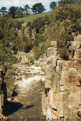


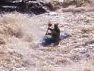
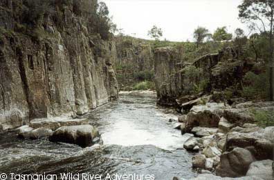
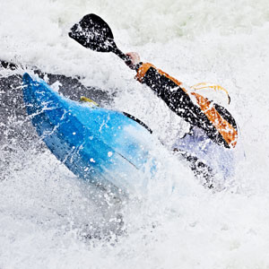
There are a number of runs which can be done on this length of river, they can all be paddled together, but it can really take it out of you, if it is in flood. I personally have paddled the lower section on a number of occasions at different heights from small flood to almost no water at all. It would have to be one of the most popular spots around Launceston, as the South Esk and North Esk can be in flood at different times, giving residents more than one option. There are 3 main trips on the North Esk ranging from 6 to 17 km. You can also paddle down from the St. Patrick's River at Nunamara which is a 22 km trip to the main get out point. The river rises and falls very quickly after continuous rain, unfortunately due to excessive logging of the upper reach of this river system, but still is a reliable source of fun in the winter spring months. A lot of this river system is made up of large steep gorges, which you don't really want to walk out of.
North Esk River - White Hills to Corra Linn
The White Hills to Corra Linn trip is approximately 6 Km in length and the average gradient is about 10 o/oo.
Difficulty can range from grade 3-4, possibly even grade 5 in high flood (advanced grade 4?). The trip's recommended time is approximately 2 hours, but if your group has not paddled this river before leave yourself plenty of time spare, as you should really check each rapid. Personally I would leave a buffer of at least another 2 hours just in case, especially in winter as it gets dark a lot earlier
Water Level: 0.9m + is ideal. The gauge is on the southern downstream side of the Corra Linn Bridge (Grid ref. 192 069).
The first few kms are easy grade 2. A couple of kms downriver you should come across a play spot, where a couple of waves have been created by local paddlers, which can provide great surfing. Just around the next corner there is a whirlpool in the middle-right of the river. I have never seen this as a problem but you should just be aware. After a little more grade 2 you come across a grade 3 rapid called the "Zig Zag", which marks the beginning of the final gorges. This is followed by the "Bastard Rapid", a rocky grade 3 which can be quite tricky at lower heights. Inspection can be carried out initially on the right. From this point it is continuous grade 3-4. Halfway through the initial gorge is "Horseshoe Falls", an exciting 2 m drop followed swiftly by the "Diagonal Stopper" which is fairly harmless at all levels.
Not far below this point, about 200m, there is a large rock in the center of
the river. It is strongly advisable to get out here and check the two large
drops which are immediately below (even experienced runners of this river like
to check 2nd Drop as it is quite easy to get pinned). The "First Drop" has been
paddled at all levels up to 5.2m. The "Second Drop" should not be missed by
any good paddler, stay center left and sprint (maybe a little bit more to the
left depending on the height, as it is quite easy to get pinned on the RHS).
The last gorge down to the bridge is continuous grade 3 with a nasty called
"Shylocks Rock" marking the last descent, before getting out.
Exit at the bridge is on a grass verge on the left just after the bridge.
The first rapid after the bridge is quite difficult. A vicious stopper just around the bend exists at high level - above 4m. on the gauge the stopper builds up below a ledge of 1.3m. from two thirds the way across the river to completely across the river as height increases. So just be careful if it is flooding; you don't want to try and shoot that one as you will possibly get pinned.
North Esk River - Blessington Road to White Hills
Blessington to White Hills trip is approximately 17 km in distance, but if you continue to Corra Linn it's another 6 Km.
The Average gradient is 8 o/oo and the peak gradient is 50 o/oo, around "the Big Bend". The difficulty is grade 3-4 and the paddling time is about 4 hours. I would not suggest paddling from Blessington Road to Corra Linn if you have never paddled either of the trips, as you would have to provide a lot of time for checking out rapids etc. The water level should be about 4.5m, which is ideal for this leg of the trip. The gauge can be found by taking a track down to the water from the southern side of the Corra Linn Bridge (Grid ref. 192 069). The river has been paddled up to a height of 6.5m (extreme flood) but this is very big water. The entry point down to Watery Plains is good grade 2-3 water for 3 Km. When you reach the weir, portage on the left. Immediately after the weir is a tricky grade 3 rapid with large hidden rocks in the center. These can be avoided by keeping to the extreme left or starting right center and edging quickly to the right bank. The river continues at grade 2 to the "Big Bend" where it turns abruptly to the right (Grid ref. 293 070).
The next section is fairly straight forward with large waves and holes to the Stromboli rapid which is about 2.5 km down from the St. Patrick's, around a slight left hand corner. A difficult inspection can be carried out on the left. It is usual to start on the extreme left and move to the right of the haystack in the center. The section below the Stromboli rapid is continuous grade 3. In high water it is continuous large waves with easy to avoid stoppers. The final few hundred meters are flat and willow bound. The "Big Bend" is continuous grade 3-4. This can be portaged across the hill on the left (from the start of the "Big Bend", about half an hour walk).
The "Big Bend" is very steep and flows through a narrow gorge with only difficult walkouts on the left. Without incidents it takes an hour to paddle, but it is excellent water. The initial rapid is an "S" shape from left to right. Inspection is on the right. The river then drops rapidly through large boulders and turns to the left. In the next 300m are two waterfalls which are particularly difficult at high levels (5.2m at Corra Linn Bridge). They can be inspected by a difficult bush trip on the left. The first is runnable in the center, the second on the left. After this is 1 Km of continuous hard grade 3, which usually needs no inspection. When you reach a suspension bridge, the rapids have ended in this section and the St. Patrick's River joins on the right.
St. Patrick's River - Nunamara to White Hills
The St. Patrick's River trip is approximately 11 Km + 11 Km on the North Esk
River to reach the exit point at White Hills.
The gradients average is about 14 o/oo on St. Patrick's and 12 o/oo on the North
Esk river. The peak gradient is 20 o/oo around "the High Spur" (Grid ref. Eg
265 117). The difficulty is grade 3 to 4 and this section takes about 6 to 7
hours paddling.
The St Patrick's needs a lot of water to increase its level, about 2 to 3 days of continuous heavy rain is needed.
The river begins with a few simple grade 2 rapids building up to hard grade 3 to 4. These sections can be portaged on the left, but could be avoided completely by crossing "the High Spur" on the left (Grid ref. 265 117). At high levels the section can be paddled through the left, then center. At low levels the section is very tight and rocky. After this the river is reasonably simple until the North Esk.
How to get there
The North Esk river is about a 20 minutes drive from Launceston heading out through St. Lonards, toward Ben Lomand National Park, which is actually the source of the North Esk.
The Grid ref. points relate to Tasmap: 1:100 000 South Esk, St. Patrick's (Land Tenure Index Series).
North Esk River - White Hills to Corra Linn
Entry Point: White Hills. There is a short road down to the North Esk from
the Blessington Road (C401) (Grid ref. 213 053) this is a private driveway so
please be considerate, don't drive down it, park at the top and walk down the
drive way.
Exit Point: Exit at the grassy bank just below the Corra Linn Bridge on the
LHS. (Grid ref. 192 069).
North Esk River - Blessington Road to White Hills
Entry Point: A point where the Blessington Road (C401) meets the river (Grid
ref. 324 060).
Exit Point: White Hills. There is a short road down to the North Esk from the
Blessington Road (C401) (Grid ref. [South Esk] 213 053). or continue to the
Corra Linn Bridge (Grid ref. 192 069) add another 6 Km.
St. Patrick's River - Nunamara to White Hills
Entry Point: At the Tasman Highway Bridge at Nunamara (Grid ref. EQ 250 178).
Exit Point: White Hills. There is a short road down to the North Esk from the
Blessington Road (Grid ref. [South Esk] 213 053).

Info source
Dave - Tassiepaddle


 Get for free:
Login to post here


 |