

The Global Paddling Community
Independent - Daily
Login / Connect
Forums
SUPzero Forums
Market
- Small Pyranha Loki for sale » Hi Charles, Unfortunately this post is over 4 years old so I would imagine the boat has been sold... (FS - North America - US)
- Necky Blunt for sale » Is your boat still For sale... (FS - Africa)
- WTB Jackson Funrunner 60 » Looking for a Funrunner 60... (FS - North America - US)
 | |
[please login to make this ad block disappear]
Articles
Amazon Update: Special PL Q&A with Amazon Expeditioner Rocky Contois
 Amazon Update: Special PL Q&A with Amazon Expeditioner Rocky Contos.
|
Contos and his Cause: Taking a break on the banks of Peru's Mantaro.
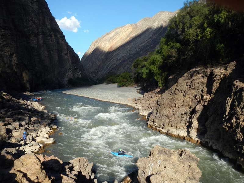 The Rio Maranon, which Contos likens to the Colorado's Grand Canyon.
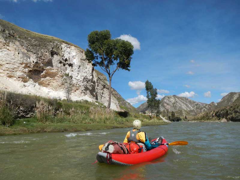 A calm stretch of the Mantaro.
 My most important river-related finding last year was that the true Upper Amazon (Rio Marañon) passes through an incredible, clean 412-mile Class IV big water section that I call the Grand Canyon of the Amazon."
It’s been a helluva year for expedition kayaker Rocky Contos. First descents in Peru, the discovery of a possible new source of the Amazon, a race down the world’s longest artery, a book coming out, a feature in Canoe & Kayak magazine, and more. We caught up with him during a brief moment out of his skirt for the low-down on his latest South American shenanigans…
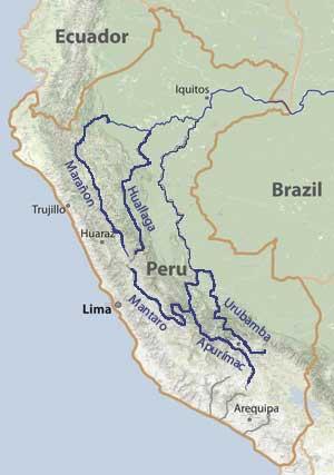
PL: Tell us about your descents of the various main stems of the Amazon from June-November last year…seems like quite a year: Contos: I’d been planning to go back to school for an MBA, but before that I wanted to do one last major paddling expedition to Peru. I had always wanted to paddle the Marañon as it seemed to be a big Grand Canyon style river. But I also wanted to do some classics like the Cotahuasi, Colca, and maybe part of the Apurimac. In gathering information for my planned descents, I made pretty major geographical discovery about the source of the Amazon. This will be the subject of other publications and I can’t discuss details yet. So I shifted my plans based on my discovery to paddle all the headwaters of the Amazon and was considering continuing all the way through the end of the river to the Atlantic. What I ended up accomplishing was the paddling descents of the four main headwater streams of the Amazon: Ríos Apurímac, Mantaro, Marañon, Urubamba (plus the Ene-Tambo); and then finishing the rest of the flatwater Marañon, Ucayali, and Amazon rivers on passenger boats. I carried GPS units down each river to obtain accurate measurement of lengths. It all took over six months, starting on May 1 on Río Mantaro and ending Nov.7 when I stood at the mouth of the Amazon. Much of the Mantaro and a section of the Marañon had never been paddled, so there was some significant first descent involved. PL: You say the Maranon is like the Grand Canyon…how so? Contos: This was perhaps my most important river-related finding last year - that the true Upper Amazon (Rio Marañon) passes through an incredible, clean 412-mile Class III-IV big water section of river that I call the Grand Canyon of the Amazon. It’s comparable to the Grand Canyon in terms of beauty, water levels, interesting excursions, amazing camps, and difficulty. It's one of the most fantastic trips I've ever done. Last year I paddled it with my wife in a cataraft and two Class III-IV kayakers over 28 days. Our trip wasn't a first descent (it was first paddled by John Wasson and crew in 1977), but it seems no other group realized how special this river is. I loved it so much that I want to do it again and again. I'm organizing two other trips through SierraRios for September to October and January to February [See www.SierraRios.org for more info]. PL: Tell us about the dams planned for the Marañon? Contos: Although the Marañon is currently free-flowing, in 2010 then-president Alan García signed a pact with Brazil to provide thousands of megawatts of hydropower for export, declaring the damming of the Marañon "in the national interest". So various studies were undertaken to forward plans for 15-20 hydroelectric dams on the river, including several mega projects in the jungle. People can read more about the planned dams atSaveRioMaranon. Basically, hydro dams are planned for the entire length of the river in the Andes, leaving little or no free-flowing river. This will disrupt the mainstem source of the Amazon, alter silt deposition, destroy habitat and migration patterns for fish and other acuatic life, displace thousands of residents along the river, and destroy a national treasure. All the dams currently are still are only in the planning stages, but construction might start soon, especially on the Chadin2 and Cumba4/Veracruz dams. It’s imperative to take action now to stop them. My web page links to a petition to sign that will be handed to President Ollanta Humala. PL: What can people do to help stop the dams? Contos: All the dams currently are still are only in the planning stages, but construction might start soon. It’s imperative to take action now to stop them. See the SaveRioMaranon webpage for more information. But at a minimum, please sign a petition that will be handed to President Ollanta Humala. If you'd like to do more, write a letter of your own. Also make the issue known. Check out the river for yourself. SierraRios is organizing more trips down the Marañon in the future that are open to anyone to join. See the SierraRios webpage for more details. PL:We understand that you’re under obligation to Nat’l Geo to remain quiet about a “new” possible source of the Amazon…what can you tell us about it? Contos: That's right. I can't discuss my discovery of the "most distant source" of the Amazon. But Grayson Schaffer at Outside magazine did release some information about it - basically that it's up on Río Mantaro, and that I did the first descent of the entire river with James Duesenberry. More specifics on the source location will have to await publication of the scientific paper in AREA and the news release from National Geographic. I will say this - it's a much more complicated story than I or anyone imagined before - and actually has a lot of twists and interesting features that nobody knows about yet. So even though some information and photos were published by Canoe & Kayak, even they are not getting the full story. Of course, everything is described in my book, tentatively titled "First Descent of the Amazon". PL:What do you like about paddling in Peru so much? Contos: Peru is the best country for expedition style whitewater journeys in all of Latin America. The country offers so many big, clean, beautiful and long rivers - from the deepest canyons in the Americas (Rios Colca and Cotahuasi) to the headwaters of the Amazon, to the sacred rivers of the Incas. The Andes are spectacular and only second in stature and height to the Himalaya. So although Peru isn't really a waterfall Mecca like southern Chile or parts of Mexico, it can't be beat for longer expedition type runs. I've paddled nearly every river in Mexico, a country over twice the size of Peru, and have to say that Peru is far better for offering beautiful expedition trips with consistent water levels that can be done with raft. PL: Tell us about your book. What prompted it and when will it hit the shelves? Contos: It’s tentatively titled "First Descent of the Amazon" which will cover the history of descents of the "Amazon," focusing on the Andes, what is considered the "source", my discovery, and the descriptions/descents of Ríos Mantaro, Apurimac, Urubamba, Ene, Tambo, Ucayali and then the rest of the Amazon. I have to write it and get all the details out there since it appears no media outlets are going to do so. There's so much to the story - the history, geographical facts and definitions, making my discovery, confiding news to West Hansen and his subsequent betrayal, help from Piotr Chmielinski, near disastrous swims on the Mantaro, dams on the river and their implications, guiding my blind friend and kayaker Erik Weihenmayer on the Apurimac, visiting Machu Picchu via paddling to it, facing the Ashanínka in the jungle, dealing with thieves in Pucallpa, and tribulations at arriving at the actual mouth of the river. It should be a pretty fascinating read. PL: Can you tell us more about the specifics of the various "sources" of the Amazon and your descents? Contos: Yep. Here’s some of it in a nutshell. RIO APURÍMAC: The Río Apurímac is currently considered the headwater stream of the Amazon with the actual source point up by Mt. Mismi or Mt. Quehuisha. This belief is based on an assessment of it being the longest extension upstream in the Amazon drainage (i.e., "most distant" source or point). I wanted to get an accurate measurement of the length of the river and also compare it to the other headwaters of the Amazon, so I kayaked the entire river. James Duesenberry and I started at its uppermost point on June 11 and reached Puente Cunyac on June 24. We both finished the trip through Acombamba Abyss, Pasaje, and Lower sections - but at different times. The river is a beautiful clean river, but it's also very difficult with many class Vs and portages. Although the commercially rafted sections have no mandatory portages, these sections occupy only about 10% of the river. After those, there's the notorious Acombamba Abyss, which is a great class V section with several mandatory portages. Most of the river is not good for raft trips due to the class Vs and portages. But if you can handle those, it's one of the best in the Andes. RIO MANTARO: the Río Mantaro is the brother river that joins Río Apurimac to form Río Ene. Apparently nobody had carefully measured the length of Río Mantaro previously until I did so in February last year. James Duesenberry and I completed the first full descent of Rio Mantaro over 23 days of paddling between May 1 and June 4, 2012, with Boris Trgovcich and Max Chmielinski joining us for some sections. Although Río Mantaro is one of the biggest and longest rivers in the Andes, nearly all of it was obscure to the boating community. We went into the trip only with knowledge that the final 140 km had been paddled by Richard Pethigal in October 2001. The most challenging section of river is a lower part that I call the Mantaro's Abyss, with class V rapids and several portages. The river is not an ideal river to paddle, though, suffering from a lot of trash in sections, poor water quality, and 4 dams along its length. There are some stellar parts of it though. I'll probably be offering some guided trips to the source and down the river next year in May. RIO MARAÑON: The Río Marañon was considered the headwater source stream of the Amazon for over 200 years, and it has perhaps the best claim to the title as it carries the most water of any branch at each junction. So really, Río Ucayali is just a tributary of the Marañon-Amazon. The Marañon is therefore the "mainstem source" of the Amazon, and the only upper stream of the Amazon that deserves the title of "Amazon", as was proposed by Padre Samuel Fritz in 1707 on his map. This is a similar argument to the reasoning behind naming the "Mississippi River" the larger branch that arises from Minnesota rather than the Missouri River (which is longer, but just a tributary). Río Marañon has had several descents of sections but only two complete or near-complete descents (Wasson et al., 1977 and Biggs et al., 2004). I did a raft-support 664 km trip from Puente Copuma down to the jungle at Imacita from July 1-28, along with my wife Barbara Conboy and two kayakers (Amy Begg and Mike Doktor). Barb and I continued down the rest of the Marañon to Iquitos, arriving August 5. Later I kayaked the uppermost Marañon on Ríos Lauricocha and Nupe down to the Puchka confluence with Tom Diegel (Aug31-Sep8). The Marañon is the best rafting Grand Canyon-style river I have ever done. RIO URUBAMBA: The Río Urubamba is the sacred river of the Inca, flowing through what's called the "Valle Sagrado de los Incas", is close to the Incan capital of Cusco, and flows by the citadel Machu Picchu. The river starts up by Lago Sabinacocha as Río Salcca and continues as Río Vilcanota before taking on the name of Urubamba near the eponymous town. The Urubamba was considered the headwaters source stream of the Amazon by various individuals starting in the late 19th century and through the 1960s before the Apurímac became established as the longer stream and therefore the true source. Although geographically the Urubamba has the most minimal claim to be a source of the Amazon, if one factors in history and culture, it might be considered the "cultural" source. I kayaked most of the Urubamba starting near Combapata and continuing down by Machu Picchu to Quillabamba and to near Kiteni. There is a notorious steep class V section that flows by Machu Picchu and takes 2-3 days to paddle between Chilca and Santa Teresa that flows by Machu Picchu. In fact, because there have been deaths trying to raft the section, it is officially illegal to do so. I managed to sneak into the section with a Chilean partner (Simon Yerovi) and found it an incredible section of Class V. It was the best way to arrive to Machu Picchu. I think a great raft-support trip would paddle through the Sacred Valley, skip the Class V section on the train as folks visit Machu Picchu, and then continue down from Santa Teresa into the jungle.
Paddling Life News on Playak is © and presented by:
 |
 |