
Stream: Jenny Creek starts off flat, gradually easing into class II-III boulder gardens with a stubborn presence of brush. This brush becomes part of the game and by the end of the trip you hardly notice it is there and strokes are naturally adjusted for its presence.
Joseph Hatcher early on

There might be a rapid or two that could be called class IV in the first portion of the trip, but every thing above the entrance to the gorge was boat scoutable. The entrance to the gorge is an island where the creek drops away to the left. The left side of the island has a sieve, while the far right channel was manky but can be bashed down. This island lands a paddler in a short gorge with a small ledge visible as soon as the corner is turned. After running this ledge eddy out above the obvious horizon line. At normal flows it is not hard getting out above on the right one at a time while the other boaters wait in a more generous eddy on the left or upstream.
Joseph Hatcher with the portage route above him, it could be done without ropes but we took the cautious route and pulled the boats up after us.

The horizon line is that of Jenny Creek Falls, which had a futuristic looking line, but has major consequences and was nothing we were interested in. We ate some food and enjoyed this spot, which is one of "those places" that makes you appreciate where kayaking can take you.

After eating we made the easy walk on the right and scouted the lower falls, dropping back down to the base of the first falls through a nice gully. Just downstream of Jenny Creek Falls is a narrow alleyway through towering walls, there is a small ledge at the base of this chasm that is best boofed on the right.

Exiting the short alley is Lower Jenny Creek Falls, an easy boof on the left or a cascade on the right. We went left, beware a shelf in the landing if you are too far left.


Below the falls the whitewater picked up to class IV, it was a little tricky with all the brush but everything went minus one glaring exception. Along the right side of a steeper island a landslide had recently deposited some debris in the creek that made for a nasty sieve, one I don't think you would come out of. We were tempted to read and run that channel before we knew this, but made the right choice to take the prudent route and scout. We paddled down the left channel as far as we could and then portaged back into the right channel below the sieve once we saw it was over there.

Below the sieve are two miles of busy whitewater, there are a lot of rapids in the lower part of the run. It's class IV, but the low visibility and brush can make the rapids feel half a class harder than they are, though there were no wood portages in 2017. Every now and then a rapid is more channelized than the others and creates fun hydraulics. There are a couple small slides and a lowhead dam (runnable) near the end of the section. We didn't stop much so I have no photos from this part of the run, check out oregonkayaking.net for more photos and info. Note: Do not use the directions on that page for shuttle. That route adds almost 2 hours onto a shuttle that can otherwise be done in about 20 minutes.

Below the sieve are two miles of busy whitewater, there are a lot of rapids in the lower part of the run. It's class IV, but the low visibility and brush can make the rapids feel half a class harder than they are, though there were no wood portages in 2017. Every now and then a rapid is more channelized than the others and creates fun hydraulics. There are a couple small slides and a lowhead dam (runnable) near the end of the section. We didn't stop much so I have no photos from this part of the run, check out oregonkayaking.net for more photos and info. Note: Do not use the directions on that page for shuttle. That route adds almost 2 hours onto a shuttle that can otherwise be done in about 20 minutes.
Access: Follow Interstate-5 to Hornbrook California, take exit 789 onto Copco Rd. Follow Copco Rd 15.3 miles along the north side of the Klamath River and Copco Reservoir to where it crosses over Jenny Creek. There is a large gravel parking area on the East side of the bridge that serves as the take out and a place to gauge water level. 41.9765, -122.3987
To get to the put in, continue East on Copco Rd 3.5 miles before turning left onto Fall Creek Rd. Follow Fall Creek Rd 2.7 miles to a point where large and obvious powerlines cross over the road. Park under them: 42.0176, -122.3414
Hike: You can follow the powerlines down to the creek, lowering boats a few times near the end. Or, take the route we did that is shown on this map, breaking away from the powerlines before the going gets steep. Our put in: 42.0232, -122.3584
Click photo to enlarge

Notes:
- Just North of the powerlines there is a private gate on Copco Rd.
- I made the shuttle in my Subaru with dry roads, but there were a couple spots that required attention. A commuter car might not work.
- From Joseph: "This is a flat, very easy walk and greatly reduces shuttle. Even turn it into a bikeable shuttle. Recommend bringing a gps or phone with map loaded for hike in, there was some other faint roads in there that could get you confused."
Flows: I believe the following two gauges can be extrapolated to give you a good idea of what is going on with the flows on Jenny Creek. This is what I would look for on a return trip, based off two data points.
SF Little Butte Creek : 200+ cfs *This is the gauge I would be most confident in.*
Spencer Creek: 100+ cfs
Here is what those gauges looked like the day we did the run.


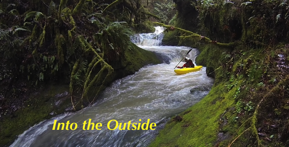
Here is what the creek looked like at the take out the day we ran it, the stream is going around an island here. We had a healthy low flow. I would not be interested in trying this creek at high levels because of the blindness and branches.

----------------------------------------------------------------------------------------------------------------------
Joseph returned to the creek with the SF Little Butte Creek gauge dropping from 145-120 and had this to say about there trip on 4/28/2019.

--------------------------------------------------------------------------------------------------------------------
We did not know about those gauges the day we paddled the creek, so we were going off some in-depth research and educated guessing Joseph had done. He used the following process to guesstimate whether Jenny would be running for our trip:
I looked at all of the gauges mentioned in this document.
Some of those with data in the 1920's are not online but some of them that are in the 1950-2000 are still online and if you look through the data can garner some benefit. Yes, that was tedious but thorough.
I also know that the guys from Oregon Kayaking went on Memorial day weekend. So I figured that was kind of on the late side and I should shoot for something earlier.
Ultimately, I think anything over 1000 cfs on this gauge would work. I would **guess** anything over 3000 to be high.
I think on good snow years, this runs way more days than people realize.
I do see that there is a discounted warning on that guage website,"Turbidity data collection will be discontinued May 1, 2017, unless new funding partners are found.", but it is still operational.
---------------------------------
The nearest USGS gauge was Big Butte Creek Near Mcleod. We were there on April 21, 2017. We had a good snow pack that year and warm weather that week. I am not confident the Big Butte gauge has a useful correlation to Jenny, but if it was the only thing available I'd go for 300+ cfs.

-jacob
No comments:
Post a Comment